Discussion
Loading...

Post

  • About
  • Code of conduct
  • Privacy
  • Users
  • Instances
  • About Bonfire
Phil Stooke
@PhilStooke@mastodon.social  ·  activity timestamp 2 weeks ago

Time for a new thread. I have been wanting to look at something very different which would not normally be associated with me... but it will take some setting up, so it will come later. For now, I want to look at the amazing Viking Lander missions. After Apollo, Viking was the next giant leap. Flyby and orbiter missions are fine but a landing on another world is something special, and I still take joy in seeing a new landscape for the first time. So here we go...
#mars #viking

  • Copy link
  • Flag this post
  • Block
Phil Stooke
@PhilStooke@mastodon.social replied  ·  activity timestamp 2 weeks ago

You all know Viking but I hope I can show you some things that are not so well known. Let's start with landing site selection. The Viking Project Science Steering Group first met in February 1969. Think about that date - the only close-up images taken by then were from Mariner 4. The Viking Landing Site Working Group started in September 1970 - they now had Mariner 6 and 7 images. But so little was known about the planet - how could sites be chosen? We'll see tomorrow.
#mars #viking

  • Copy link
  • Flag this comment
  • Block
Phil Stooke
@PhilStooke@mastodon.social replied  ·  activity timestamp 2 weeks ago

VIking landing sites had to be between 30 N and 30 S, and at low elevation (denser atmosphere for the parachute and maybe for biology). Topographic knowledge was rudimentary, most details had to wait for Mariner 9 imaging, but in early December 1970 the first list appeared from the landing site working group. This map shows these first sites. The base map is Mariner 6 and 7 images, the best available. Ellipses are 400 by 840 km across, huge by our standards today.
#mars #viking

The first list of Viking landing sites drawn up by the Viking Landing Site Working Group in December 1970, drawn on a base mosaic of Mariner 6 and 7 images. The map shows the Viking Zone (between 30 north and 30 south), roughly outlined high terrain to be avoided (though elevations were VERY poorly known), and 15 ellipses marking the suggested sites. Two were recommended, in Hellas and Thoth-Nepenthes (which today we would regard as part of Isidis)
  • Copy link
  • Flag this comment
  • Block
Phil Stooke
@PhilStooke@mastodon.social replied  ·  activity timestamp 2 weeks ago

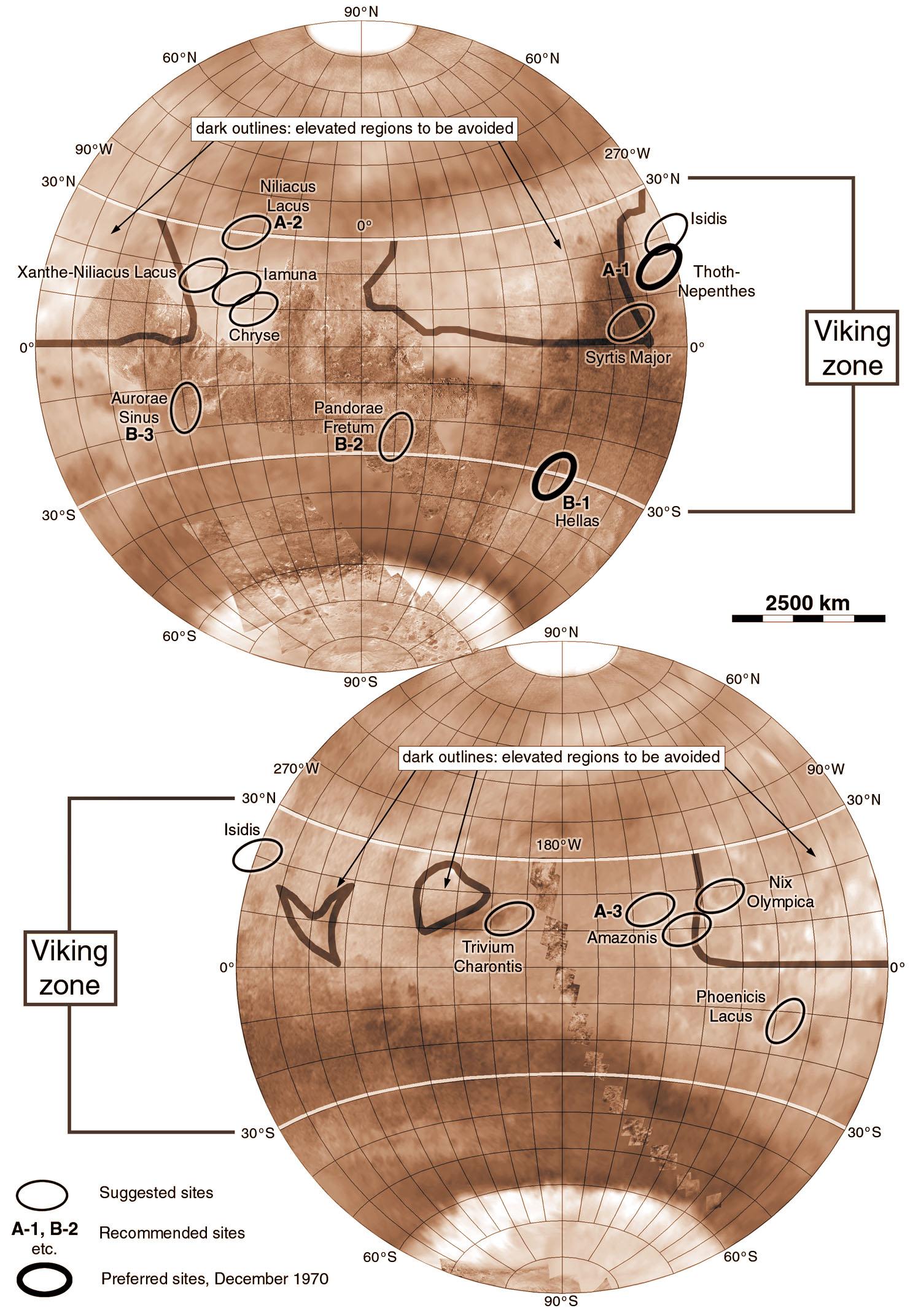
Elevations came from 6 spacecraft occultations (2 each, entry and exit, for 3 Mariners), Earth-based radar and carbon dioxide spectra. The names are 19th Century albedo feature names - Nix Olympica, snows of Olympus, is what we now call Olympus Mons. A, A2, A3 are Viking 1 sites, B1, B2, B2 are for Viking 2. Preferred sites were in Hellas and Thoth-Nepenthes (part of Isidis, we would call it now). The 2 landers had to be far apart so A2 + B3 or A1 + B1 could not both be selected.
#mars #viking

  • Copy link
  • Flag this comment
  • Block
Phil Stooke
@PhilStooke@mastodon.social replied  ·  activity timestamp 2 weeks ago

It's hard to believe now how little was known about Mars when that first map was compiled. Mariner 9 changed that in 1971-72. Its job was to map the planet's features, and this is when the 'Wonderworld' was revealed - the volcanoes, canyons, channels etc. we know today. In April 1972 the landing site group revised the landing zone to 25 north to 25 south, and the Viking Data Analysis Team recommended extra imaging of potential landing sites, mapped here.
#mars #viking

A map of Mars in 2 hemispheres based on early Mariner 9 images (northern latitudes are still blank but were filled in later). On it are mapped broad regions screened for Viking landing sites, and over 40 targets which looked interesting for landing. They became targets for extra imaging later in Mariner 9's mission, but not all of them could be imaged before the mission ended.
  • Copy link
  • Flag this comment
  • Block
Phil Stooke
@PhilStooke@mastodon.social replied  ·  activity timestamp 2 weeks ago

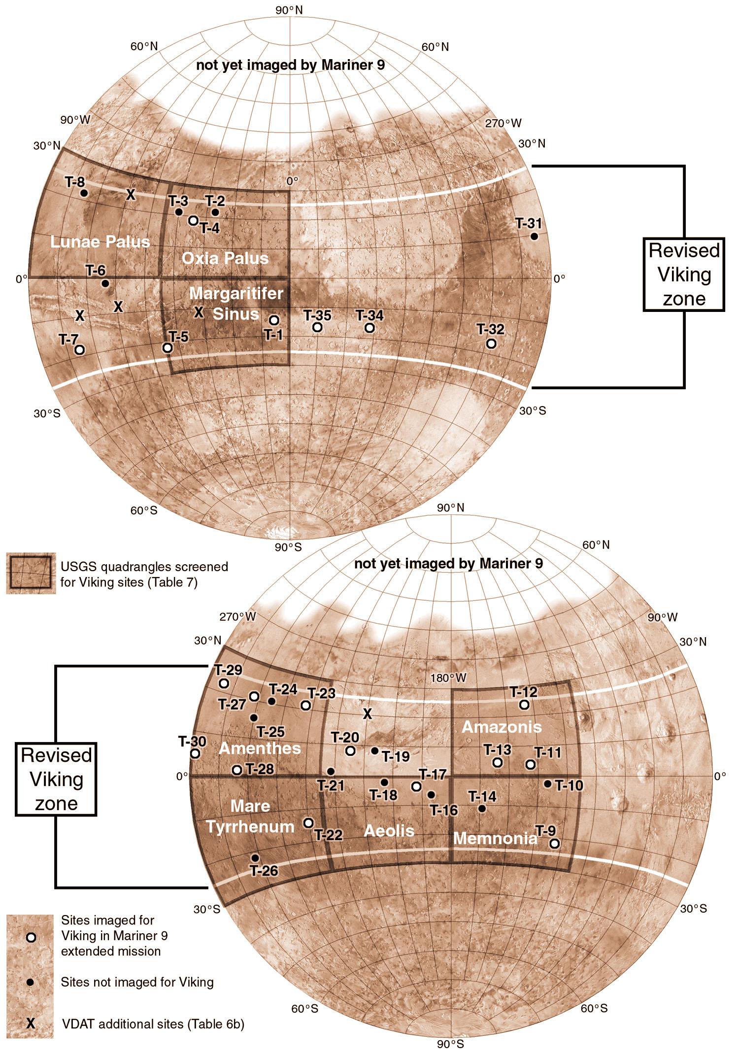
That map shows the USGS map quads which were screened for sites. Circles show targets for more imaging (especially high resolution frames), and some extra sites were added to the list (X symbols). Only the white targets could be imaged before the mission ended.

Images were not the only useful inputs to the process. Earth-based radar could probe the sub-Earth latitude showing surface elevation and roughness, but interpretation was difficult. What should we trust?
#mars #viking

  • Copy link
  • Flag this comment
  • Block
Log in

Open Science

We are a network of scientists, developers and organizations building the next generation of digital spaces for open science.

Open Science: About · Code of conduct · Privacy · Users · Instances
Bonfire open science · 1.0.0-rc.2.35 no JS en
Automatic federation enabled
  • Explore
  • About
  • Members
  • Code of Conduct
Home
Login